
Friends of Herring River
1580 Route 6 #5 (mailing address, 1.1.24)
Wellfleet, MA 02667
(508) 214-0656
info@herringriver.org
SUPPORT US
FOLLOW US
Restoration Area Maps

An 1887 map of western Wellfleet showing the Herring River Estuary more than twenty years before the original 1909 dike was built. Note that the river still had its naturally meandering course, that Duck Harbor was still open to the Bay, that Eel Creek (now Pole Dike Creek) nearly joined the harbor near the current location of Howland Lane and the Wellfleet Public Library, and that Mill Creek (just north of Chequessett Neck) fed a large area of salt marsh.

Some of the early bridges, dikes, and roads built by the Town of Wellfleet to provide overland access to settlements on Griffiths Island (now Griffin Island), Myricks Island (now Merrick Island), Bound Brook Island, and Coles Neck. Note the track of the Cape Cod Railroad, which was extended into Wellfleet in 1869.

The dike was installed in 1909 to substantially reduce the flow of the Herring River. In the 1920’s, to further hasten the drainage of the wetlands, the main stem of the river was deepened, straightened and channelized in several areas north of High Toss Road.

The effects of diking included a dramatic decrease in the amount of salt marsh in the estuary. Once covering approximately 1,100 acres, today’s viable salt marsh covers a mere 10 acres, less than 10% of its original size.
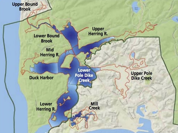
A view of the extent of Phase 1 of the Project, as currently planned.

An overview of the entire Project, as currently planned. The various sub-areas are listed, as well as their approximate acreage.

An 1860 bathymetric map of Wellfleet Harbor, Jeremy’s Point, and Cape Cod Bay, showing Billingsgate Island (now submerged at high tide) and Billingsgate Shoal.